


 RSS news
 For some 600 million island-dwellers -- nearly one-tenth of the world’s population and representing one in three United Nations Member States -- biodiversity is integral to their subsistence, income, well-being and cultural identity.
Half the world’s marine resources lie in island waters. Biodiversity-based industries such as tourism and fisheries account for more than half the gross domestic product of small island developing states. Coral reefs alone provide an estimated $375 billion annual return in goods and services. Many island species on land and sea are found nowhere else on Earth. Legacies of a unique evolutionary heritage, they hold the promise of future discoveries -- from medicines and foods to biofuels.
Yet, reflecting a global pattern, island biodiversity is being lost at an unprecedented rate in the face of growing risks. Rising sea levels caused by climate change, ocean acidification, invasive alien species, overfishing, pollution and ill-considered development are taking a heavy toll. Many species face the prospect of extinction. People’s livelihoods and national economies are suffering.
The process to define a post-2015 development agenda and the Third Conference on Small Island Developing States in Samoa in September of this year both offer opportunities to attend to the unique needs of small island developing states and reverse the global decline in biodiversity. Because of their vulnerability, small island developing states are demonstrating a growing understanding of the links between healthy ecosystems and human well-being. Many have made local, national and regional commitments to conserve and sustainably use biodiversity, including through ratifying important instruments such as the Nagoya Protocol on Access to Genetic Resources and the Fair and Equitable Sharing of Benefits Arising from their Utilization. I call on all countries around the world to follow suit and ratify the Protocol without delay.
Around the world, many innovative partnerships are being forged to preserve marine and coastal resources, enhance resilience to climate change and develop sustainable tourism, fisheries and other industries. On this International Day, let us commit to adopting, adapting and scaling up best practices so we can protect fragile ecosystems for the benefit of all the islanders -- and indeed people everywhere -- who depend on them.
The GEOSS Architecture Implementation Pilot (AIP) develops and deploys new process and infrastructure components for the GEOSS Common Infrastructure (GCI) and the broader GEOSS architecture.
To present the GCI an "Introduction to the GEOSS Common Infrastructure (GCI)" virtual workshop will be held today 21 May 2013 at 14:00 UTC.
Agenda: In this 1 hour session we will take a "Tour of the GCI - everything you wanted to know about GCI" from a user perspective (outside view of the GCI; what is the goal of the GCI, what are ‘resources', Data-CORE and much more ...) (this includes a demo of the GeoPortal) and technical perspective (inside view the GCI; architecture and interfaces). We estimate a kif-kif split between user and technical perspective (don’t worry if you are not a propeller-head, the technical view will give you additional insight).
GEOSS speakers are (in alphabetical order): Doug Nebert (USGS), Guido Colangeli (ESA), Mattia Santoro (CNR), Steve Browdy (IEEE).
Intended audience:
- if you are new to GEOSS or AIP
- knew GEOSS or AIP from a while back and need a refresher
- in need for a general refresher
- general interest in GEOSS (but not a participant in AIP)
Virtual meeting details: https://www4.gotomeeting.com/join/628333311

GEO is a voluntary partnership of governments and organizations that envisions "a future wherein decisions and actions for the benefit of humankind are informed by coordinated, comprehensive and sustained Earth observations and information." GEO membership includes 89 nations and the European Commission, and 77 Participating Organizations comprised of international bodies with a mandate in Earth observations.
GEO Appathon 2014 is designed to create new, exciting and easy-to-use Apps using Earth observation data available through GEO’s Global Earth Observation System of Systems (GEOSS). GEOSS is a unique, web-based clearinghouse that provides access to more than 65 million data records from archives spread across the globe. (www.geoportal.org)
"GEO Appathon 2014 is one of the critical next steps in the evolution of GEOSS to create mechanisms to readily convert data into information and tools for decision makers across society," stated Barbara J. Ryan, Secretariat Director of GEO. "The Appathon is an important leap forward in unleashing the power of Earth observations."
Apps will focus on addressing environmental and societal challenges facing decision leaders and individual citizens in developing countries across nine essential areas: agriculture, biodiversity, climate, disasters, ecosystems, energy, health, water and weather.
"Access to better information, in the hands of people who can use it every day, is a major step forward. This appathon goes beyond the open data movement. The aim is to turn data into decisions," said Carrie Stokes, Director of USAID’s GeoCenter.
In addition to USAID, partners in the GEO Appathon include Esri, European Space Agency, Geospatial Media, GISCloud, Microsoft, National Research Council of Italy, and Open Geospatial Consortium.
Participation in the GEO Appathon is open to any non-commercial entity, individual or team from any background in any country. Apps can be created for any of the main operating systems, as well as open source platforms, and can be designed for any type of portable device. All Apps will be judged and the top winners will receive a cash prize and a year-long GEO network endorsement and publicity for the App. Registration for the GEO
Appathon remains open through July 31st. Qualifying Apps must be received by August 31, 2 014.


Philosophical Transactions of the Royal Society B (2014) doi: 10.1098/rstb.2013.0190
Assessing and predicting ecosystem responses to global environmental change and its impacts on human well-being are high priority targets for the scientific community. The potential for synergies between remote sensing science and ecology, especially satellite remote sensing and conservation biology, has been highlighted by many in the past. Yet, the two research communities have only recently begun to coordinate their agendas. Such synchronization is the key to improving the potential for satellite data effectively to support future environmental management decision-making processes. With this themed issue, we aim to illustrate how integrating remote sensing into ecological research promotes a better understanding of the mechanisms shaping current changes in biodiversity patterns and improves conservation efforts. Added benefits include fostering innovation, generating new research directions in both disciplines and the development of new satellite remote sensing products.

A new updated version of Euro+Med Plantbase was made available online in the middle of April 2014. For the first time, the economically important gymnosperms (coniferous trees), and the genus Thalictrum, as the first part of the large Ranunculaceae family, are treated in Euro+Med Plantbase.
Euro+Med Plantbase integrates and critically evaluates information from Flora Europaea, Med-Checklist, the Flora of Macaronesia, and from regional and national floras and checklists from the area as well as additional taxonomic and floristic literature. This is complemented by the European taxa of several families taken from the World Checklist of Selected Plant Families and of the Leguminosae from the International Legume Database and Information Service ILDIS. By April 2014 it provides access to 187 plant families, corresponding to ca. 92 % of the European flora of vascular plants.
The Euro+Med Plantbase web portal is accessible at http://ww2.bgbm.org/EuroPlusMed/.
Web services for Euro+Med merged with Fauna Europaea, ERMS, and Index Fungorum are provided by VLIZ at http://www.eu-nomen.eu/portal/webservices.php. The services will be also registered for use in EU BON in summer 2014.
The Heinz-Nixdorf-Chair for Distributed Information Systems at the Friedrich Schiller University of Jena (Germany) invites applications for a fully funded PhD student position in Biodiversity Data Visualization for the data management project of the Biodiversity Exploratories (BE) Priority Program.
Deadline for application: 2nd, May 2014
Start date: June 2014 or later
What this is about
The data management project provides the platform for data storage and information exchange for the projects of the DFG Priority Program "Biodiversity Exploratories". Examples of the thematic focus of the projects include botany, forestry, soil, animal, fluxes, modeling, and remote sensing. This diversity is reflected in the format, structure, and semantics of their data which we manage.
Tasks in this project will be centered on the investigation and development of novel visualization methods and user-friendly tools for exploration, search and discovery, quality assurance and integration of the heterogeneous, large volume biodiversity data. Overall, the study should contribute to the science of visualization for big-data-driven biodiversity research.
More information on the requirements, conditions and how to apply find in the official job offer attached below.

The April 2014 mirror updates of FishBase (www.fishbase.ca and www.fishbase.us); are now available online.
FishBase stats to date: ( 32800 Species, 303100 Common names, 53900 Pictures,
50200 References, 2110 Collaborators, 700000 Visits/Month )


Researchers and the public can now have immediate access to data underlying discovery of new species of life on Earth, under a new streamlined system linking taxonomic research with open data publication.
The partnership paves the way for unlocking and preserving a wealth of 'small data' backing up research conclusions, which often become lost within a few years of an article's publication in an academic journal.
In the first example of the new collaboration in action, the Biodiversity Data Journal carries a peer-reviewed description of a new species of spider discovered during a field course in Borneo just one month ago. At the same time, the data showing location of the spider's occurrence in nature are automatically harvested by the Global Biodiversity Information Facility (GBIF), and richer data such as images and the species description are exported to the Encyclopedia of Life (EOL).
This contrasts with an average 'shelf life' of twenty-one years between field discovery of a new species and its formal description and naming, according to a recent study in Current Biology.
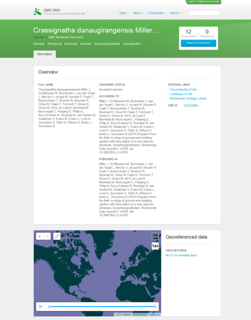 A group of scientists and students discovered the new species of spider during a field course in Borneo, supervised by Jeremy Miller and Menno Schilthuizen from the Naturalis Biodiversity Center, based in Leiden, the Netherlands. The species was described and submitted online from the field to the Biodiversity Data Journal through a satellite internet connection, along with the underlying data . The manuscript was peer-reviewed and published within two weeks of submission. On the day of publication, GBIF and EOL have harvested and included the data in their respective platforms.
The new workflow established between GBIF, EOL and Pensoft Publishers' Biodiversity Data Journal, with the support of the Swiss NGO Plazi, automatically exports treatment and occurrence data into a Darwin Core Archive, a standard format used by GBIF and other networks to share data from many different sources. This means GBIF can extract these data on the day of the article's publication, making them immediately available to science and the public through its portal and web services, further enriching the biodiversity data already freely accessible through the GBIF network. Similarly, the information and multimedia resources become accessible via EOL's species pages.
One of the main purposes of the partnership is to ensure that such data remain accessible for future use in research. A recent study published in Current Biology found that 80 % of scientific data are lost in less than 10 years following their creation.
Donald Hobern, GBIF's Executive Secretary, commented: "A great volume of extremely important information about the world's species is effectively inaccessible, scattered across thousands of small datasets carefully curated by taxonomic researchers. I find it very exciting that this new workflow will help preserve these 'small data' and make them immediately available for re-use through our networks."
"Re-use of data published on paper or in PDF format is a huge challenge in all branches of science", said Prof. Lyubomir Penev, managing director of Pensoft and founder of the Biodiversity Data Journal. "This problem has been tackled firstly by our partners from Plazi who created a workflow to extract data from legacy literature and submit it to GBIF. The workflow currently launched by GBIF, EOL and the Biodiversity Data Journal radically shortens the way from publication of data to their sharing and re-use and makes the whole process cost efficient", added Prof. Penev.
The elaboration of the workflow from BDJ and Plazi to GBIF through Darwin Core Archive was supported by the EU-funded project EU BON (Building the European Biodiversity Observation Network, grant No 308454). The basic concept has been initially discussed and outlined in the course of the pro-iBiosphere project (Coordination and policy development in preparation for a European Open Biodiversity Knowledge Management System, addressing Acquisition, Curation, Synthesis, Interoperability and Dissemination, grant No 312848).
Original source:
Miller J, Schilthuizen M, Burmester J, van der Graaf L, Merckx V, Jocqué M, Kessler P, Fayle T, Breeschoten T, Broeren R, Bouman R, Chua W, Feijen F, Fermont T, Groen K, Groen M, Kil N, de Laat H, Moerland M, Moncoquet C, Panjang E, Philip A, Roca-Eriksen R, Rooduijn B, van Santen M, Swakman V, Evans M, Evans L, Love K, Joscelyne S, Tober A, Wilson H, Ambu L, Goossens B (2014) Dispatch from the field: ecology of micro web-building spiders with description of a new species. Biodiversity Data Journal 2: e1076. DOI: 10.3897/BDJ.2.e1076

Issue 72 of the CBD Technical Series is now out focusing on "EARTH OBSERVATION FOR BIODIVERSITY MONITORING : A review of current approaches and future opportunities for tracking progress towards the Aichi Biodiversity Targets". The issue shows how earth observation technologies can and should fit into systems for biodiversity monitoring, as well as demonstrates how these approaches could further improve relevant indicators for the Aichi Biodiversity Targets. It illustrates a clear track from observations done by remote sensing platforms through Essential Biodiversity Variables to biodiversity indicators and ultimately to the assessment of progress towards the Aichi Biodiversity Targets and ultimately in support of evidence-based decision making. EU BON is also featured in this report.
The goal of the CBD Technical Series is to contribute to the dissemination of up-to-date and accurate information on selected topics that are important for the conservation of biological diversity, the sustainable use of its components and the equitable sharing of its benefits. A large and growing body of evidence has clearly established the need to disseminate synthesis publications relevant to CBD objectives and selected reports presented at CBD meetings.
The CBD Technical Series is intended to:
- Foster scientific and technical cooperation;
- Improve communication between the Convention and the scientific community;
- Increase awareness of current biodiversity-related problems and concerns; and
- Facilitate widespread and effective use of the growing body of scientific and technical information on conserving and using biological diversity.
The full report is available here.

The SUSTAIN EU-ASEAN project aiming at establishing a more sustainable and integrated research and innovation cooperation between the EU and the ASEAN region in the areas of climate action, resource efficiency and raw materials has now published its first project newsletter.
This first issue of the SUSTAIN EU-ASEAN Newsletter contains information about the outcomes from the first project Networking and Cluster Session that took place on 23 January 2014 in Bangkok, Thailand, as well as features a news item about the forthcoming sessions scheduled for 28 Match 2014 in Brussels, Belgium. More can be found in the Newsletter available here.
The SUSTAIN EU-ASEAN coordinating action will focus on climate action, resource efficiency and raw materials issues and will aim to enhance collaboration between researchers in the EU and the ASEAN region. Addressing these issues in a coherent way is vital for sustainable development that leads to economic prosperity, social cohesion and environmental integrity. Both regions have developed innovative ideas to reduce greenhouse gas emissions, to adapt to climate change, improve resource efficiency and manage raw materials.


Care about biodiversity protection and science-policy dialogue? The second BESAFE stakeholder workshop might be just the thing for you.
The BESAFE project invites all interested policy makers, NGO representatives, decision makers and people, who argue ('lobby') for biodiversity protection to take part in its second stakeholder workshop, focusing the results from the project case studies and the best ways to make them useful through a stakeholder focused web-based tool.
The workshop will be held on 13 and 14 May 2004 at the Park Inn Brussels Midi, Brussels, Belgium. To register and participate is easy just follow this link, which will take you to an easy to follow and use registration page.
On the afternoon of 13 May BESAFE will present the results of the project’s case studies and then their use and implications will be discussed with stakeholders. The morning of 14 May is reserved for a learning workshop on the best ways to unlock and present project results. As committed stakeholder involvement is crucial to BESAFE’s success, we hope that you will be able to join us in Brussels!
In a nutshell, BESAFE investigates the effectiveness of different types of arguments in convincing policy makers to take action for biodiversity protection in a variety of circumstances. The project has two specific focus areas: the interactions of environmental protection policies between governance scales, and the contribution that ecosystem services BESAFE is committed to produce practically usable results and to make them available and easily accessible through a web-based tool. This is a goal we can clearly only achieve through input and feedback from stakeholders. BESAFE is therefore set up as an interactive project in which we inform and consult those on a regular basis.
Deadline for registration is the 1st of April 2014, but registration will be closed earlier when our limit of 25 stakeholders is reached. Due to this limited capacity, registration is subject to approval.
ANNOUNCEMENT: The February 2014 update of the FishBase (www.fishbase.us and www.fishbase.ca) and SeaLifeBase (www.sealifebase.ca) websites are now available online.
FishBase stats to date: (32700 Species, 302900 Common names, 53600 Pictures, 49700 References, 2100 Collaborators, 700000 Visits/Month)
SeaLifeBase stats to date: (126000 Species, 27300 Common names, 11900 Pictures, 18200 References, 250 Collaborators)


An international conference Adaptation Strategies to Global Environmental Change in the Mediterranean City and the Role of Global Earth Observations will take place between 10-11 June 2014 in Athens, Greece. The conference will explore the potential of earth observations and thrust climate information transfer from the science to the stakeholder application realm, in order to develop suitable adaptation measures at national and regional levels.
It will identify best adaptation programs and approaches to global environmental change in Mediterranean-climate cities. The aim is to enhance and strengthen European and international cooperation in the context of the activities within the Group on Earth Observations (GEO), and promote tools and options for adaptation strategies. The Conference will help local and regional authorities and stakeholders to gain insight on the role of EO-based services in adapting to climate chance impacts in urban hot-spot areas.
The eighth annual series of GEO European Projects Workshops will be consequently held on 12-13 June as a follow-up of the conference. The worksops are intended to bring all those interested in and actively contributing to the Global Earth Observations System of Systems (GEOSS) from all over Europe together, in order to present their work and discuss how Europe can contribute to this international effort, especially in the wake of the launch of the new EU Framework Programme for Research, Horizon 2020, and the renewal of the mandate of GEO for another 10 years through the endorsement of the 2014.
Registrations opens: 16 February 2014
Information and registration: www.mariolopoulosfoundation.gr/medcity2014

Following the GEO-X Plenary in Geneva earlier this year (15-16 January 2014), GEO now issues Revision 3 of the GEO 2012-2015 Work Plan incorporating comments from the meeting. The new work plan is available through the GEO Work Plan Information Management system.
The GEO Work Plan provides the agreed framework for implementing the GEOSS 10-Year Implementation Plan (2005-2015). It is a living document that is updated annually. The 2012-2015 Work Plan has been designed to meet the 2015 GEOSS Strategic Targets. As a result, the tasks of the Work Plan correspond to outcomes identified as being necessary to meet the Strategic Targets.
The highlighted actions in the revised work plan are as follows:
- Call for Participation (CFP) in the 6th phase of the GEOSS Architecture Implementation Pilot (AIP)
- GEOSS Common Infrastructure (GCI) - Initial Operating Capability (IOC) phase
- Data Sharing Principles implementation
- AIP information page to GEOSS Implementation
- Call for Proposals: Earth Observations in Decision Support Projects
The GEO Work Plan provides a flexible action-oriented framework for developing new projects within and across areas, and coordinating strategies and investments. Benefits and opportunities include inter-alia: fostering networking and partnerships (new contacts and collaborations); launching regional and/or global initiatives (e.g. GEO BON, GEOGLAM); providing access to data (making more data available); enlarging user-bases (users grow in numbers and diversity); developing and maintaining capacity (participants build on complementarity); increasing visibility and high-level support (e.g. through the GEO Website, Newsletter, Plenary, Ministerial); and leveraging funding for activities (funding mechanisms value contributions to GEOSS implementation, like the European 7th Framework Programme).
EU BON site data management workshop and Memorandum of Understanding
A joint workshop of the Sierra Nevada LTER site and EU BON was held on 29-31 January 2014 in Granada, Spain and was hosted by the University of Granada. The aim of this meeting was to bring together the Spanish members of the Sierra Nevada LTER site and test site partners from EU BON (WP1, WP2 and WP5) to discuss and develop a closer relationship in exchanging datasets and experiences in site management, long-term monitoring activities and technical requirements for data management.
During the fi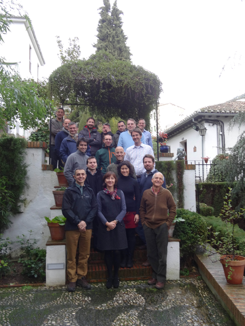 rst day of the workshop, 19 participants from EU BON, the Sierra Nevada LTER site (e.g. Regino Zamora Rodriguez and Francisco Bonet) and guests from the remote sensing EU project BIO_SOS and GBIF Spain gave an overview of their activities to obtain information on their projects and to point out likely synergies and linkages. First, the Sierra Nevada LTER site was introduced, particularly the methodologies to monitor and evaluate biodiversity and the structure of the information system Linaria was shown. Thereafter EU BON testing sites (Doñana, Rhine-Main, Amvrakikos) outlined their current activities regarding data collection, data processing and data integration, in addition to that the results of a recently conducted gap analysis of the test sites were presented. In the afternoon session of the meeting, the planned information architecture of EU BON was explained and ways outlined of how biodiversity data could be integrated.
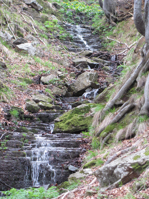
At the second day, the participants visited a highly monitored area located in the southern part of Sierra Nevada (Alpujarras) that is covered mainly by Quercus pyrenaica forests. The field trip included stops at a meteorological station, a traditional hydrological system was visited to show former human impact in the area and the functionality of a field ND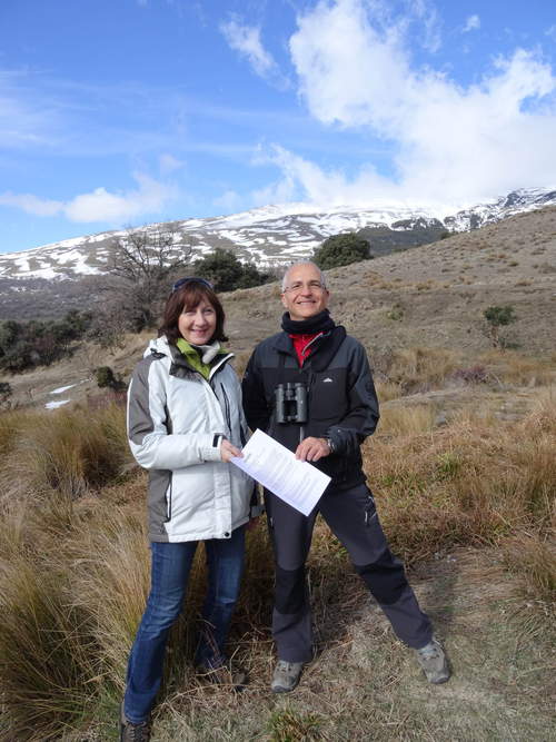 VI camera was shown. This site-trip was also used to officially hand-over the Memorandum of Understanding, signed between the University of Granada and EU BON, to strengthen the cooperation between the Sierra Nevada LTER and the EU BON test sites. Anke Hoffmann on behalf of EU BON handed the MoU to Professor Regino Zamora Rodriguez, the scientific coordinator of the Sierra Nevada Global Change Observatory. The University of Granada is now a new associate partner of EU BON, a consortium with currently 30 partners from 18 countries.
At the last day local scientists gave an overview of the research conducted in Sierra Nevada. After that session, the workshop aimed to discuss the functionality of the envisaged MetaCat (dataprovider for Metadata) approach for the EU BON test sites and the advantages of self-developed information system Linaria of the Sierra Nevada LTER site.
EU BON will further intensify the dialogue with the University of Granada and the Sierra Nevada LTER site. It is scheduled to have a further meeting at the upcoming General Meeting of EU BON (Greece, 30 March-2 April 2014) to strengthen the partnership with the LTER test site.
For further questions please contact Anke Hoffmann or Florian Wetzel
Presentations from the meeting:
Day 1
1. Zamora - Ramos - Sierra Nevada global change obs
2. Bonet - The Linaria information system
3. Hoffmann - Häuser - Introduction to EU BON
4. Juan Negro - CSIC-EBD
4. Juan Negro Donana 2
4. Juan Negro Donana 3
5. Stoll - test site Rhein - Main
6. Dailianis - test site Amvrakikos
7. Wetzel - Gap analysis
8. Palma Blonda - BIO_SOS and remote sensing
9. Pando - EU BON GBIF Granada 2014
10. Kunin- EU BON Work package 3
Day 3
1. Megia - Mendenez - Climate Change andd elevational range shifts
2. Gomez - Hybridization
3. Villar - Argaiz Long time series in high mountain lakes
4. Moreno - Vegetation changes during Holocene
Workshop Photos (Google+ | Facebook)
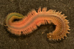
Ecosystem functioning, or the role which organisms play in an ecosystem, is becoming increasingly important in marine ecological and conservation. To facilitate such studies an international team of scientists lead by S. Faulwetter from the Hellenic Centre for Marine Research (HMRC) present the Polytraitsdatabase that aims to provide re-usable, and accessible data on marine bristle worms. The paper describing the new database was published in the innovative Biodiversity Data Journal, a pioneer in the publication of integrated biological data.
Benthic organisms participate in a number of biological processes in world water basins. Their functional diversity is an important community property demonstrating the role organisms have in the ecosystem and helping to understand how the community reacts to environmental changes. Polychaetes, or bristle worms, are marine worms famous for their peculiar shapes and often vivid coloration. More than 10,000 species are described in the class worldwide, most of which living in the shelf zone of the seas and oceans, burrowing in the sediment or swimming among the plankton.
At present, the Polytraits database contains almost 20,000 records on morphological, behavioural and reproductive characteristics of more than 1,000 species, all referenced by literature sources. All data on these engaging organisms can be freely accessed through the project website in different ways and formats, both human-readable and machine-readable. The new database presents a rich and easy to use collection, which cover morphological, reproductive and behavioural characteristics of polychaetes, as well as information on environmental preferences in an attempt to facilitate ecological research and conservation studies.
The researchers also provide a leading-edge approach to accessing, integrating and re-using the data. Through programming interfaces, the life-cycle information is automatically integrated into the Polychaetes Scratchpads, together with other data on polychaetes. Scratchpads are easy to use, adaptable, and provide powerful tools for managing biodiversity data. This taxon-centric virtual research environment allows browsing the taxonomic classification and retrieving various kinds of relevant information for each taxon, among which are also the collected biological traits.
Furthermore, the data are also accessible through Encyclopedia of Life's TraitBank which currently features over 3 million records related to more than 250 attributes for 272,720 taxa, including the Polytraits data. TraitBank serves as a provider for aggregated species trait data. All data uploaded there are archived and integrated with trait information from other sources to address issues of standardization of scientific data. This is the first complex database for marine organisms to be published in such an innovative way and demonstrates yet another example of collaboration between the data publisher Pensoft and Encyclopedia of Life.

The second plenary of the Platform met in December 2013 and agreed an ambitious work programme for 2014-2018: Details of the agreed work programme are available in the advanced meeting report of the Plenary.
The IPBES Secretariat have now issued a call for experts to help scope, advise on and deliver the work programme. Governments and relevant stakeholders can put forward nominations, from which the Multidisciplinary Expert Panel of IPBES will select a maximum of 20% of experts from the stakeholder nominations, and the rest from the government nominations.
The UK expects IPBES to make use of the best scientists/experts from all relevant disciplines - natural science, social science, economics, data and modelling and traditional knowledge, and to achieve a geographical and gender balance among those experts in the delivery of the IPBES work programme.
More information of the required topics to be covered by experts, alongside the nomination forms and how to nominate can be found in the attachments below.
 IPBES Nomination Template 312.00 KB IPBES UK Nomination Template 35.50 KB
 Official Invitation for Nomination 123.53 KB
On the 17 Jan in Geneva, the Group on Earth Observations (GEO) received unanimous endorsement to unleash the power of open data for a second decade. There was agreement to continue building on the organization’s first 10 years of pioneering environmental advances, which are designed to improve the quality of life of people everywhere. Fueled by open data, GEO’s efforts are now evident in most regions of the world. GEO is comprised of 90 member nations, the European Commission and 77 Participating Organizations.
"GEO is successfully meeting its mandate, which is to make data and other information open, accessible and easy to discover for decision makers around the world," said Mr. Janez Potočnik, European Commissioner for the Environment. "GEO’s vision is now operational, a proven force for putting sound science to work across nine essential areas: agriculture, biodiversity, climate, disasters, ecosystems, energy, health, water and weather."
GEO’s mandate is to drive the interoperability of the many thousands of space-based, airborne and in situ Earth observations around the globe. Without concerted efforts to coordinate across diverse observations, these separate systems often yield just snapshot assessments, leading to gaps in scientific understanding and hampering data fusion in support of better decision making for society. GEO aims to fill such gaps by providing a comprehensive, more integrated picture of our changing Earth. GEO is accomplishing this by establishing a Global Earth Observation System of Systems, known as GEOSS, and a Portal through which data and other information can be easily accessed at little or no cost.
"Rather than snapshot assessments, GEO gives us moving pictures of a changing planet," said Mr. Cao Jianlin, Vice Minister of the Ministry of Science and Technology of China. "Our world does not work just in the sea, on land, in the atmosphere or in space, and our policies cannot reflect individual domains either." China, for example, is partnering with 46 other GEO-member nations and several of GEO’s Participating Organizations to ensure that unprecedented data will be available to measure the effects of human activities and natural processes on the carbon cycle, the first such coordinated effort at the global level.
In South Africa, 22 nations and 5 GEO Participating Organizations recently launched AfriGEOSS with the goal of strengthening that continent’s capabilities to produce, manage and use earth observations. "This new initiative gives us the necessary framework to support informed decisions about a range of priorities, including food security, access to clean water and sanitation, natural resources, and coastal and disaster management," said Derek Hannekom, Minister of Science and Technology, South Africa.
By increasing the utility of open data about the Earth, GEO is helping to mitigate disasters, develop water-management strategies, support citizen observatories, and strengthen food security. GEO is driving the development of new tools, such as a cholera early warning system, as well as painting fuller pictures of complex environmental processes, including through global observations of ocean acidification at the global scale and observations of atmospheric greenhouse gases from space. GEO participants are also studying the footprint of mining practices, with the aim of minimizing future impacts on nearby communities and natural habitat, and focusing on links between air quality and health. There is also focus on the far-reaching consequences of melting glaciers and other serious cold-region concerns.
"The Obama Administration continues to work to catalyze the emergence of new businesses, products and services powered by the U.S. Government's open data. Increasing access to data and data sharing, both nationally and internationally, is crucial for unleashing innovation across our data-driven economy," said Dr. Patrick Gallagher, performing the duties of the Deputy Secretary of Commerce." GEO's collaborative work to integrate open data about the Earth continues to drive the development of new tools, services and scientific insights that are used around the world to support sound decision making."

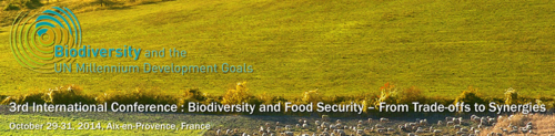
The Mediterranean Institute for Biodiversity and Ecology (IMBE, Aix-Marseille University, Aix-en-Provence, France), in its Research Group "Macroecology and Biogeography of Global Change (MacroBio)" has a 36-months PhD position open for applications. The position is funded by the European Commission through the FP7 Research Project OPERAs and affiliated to the French National Scientific Research Centre (CNRS).
The topic is the broad-scale spatial mapping and quantification of ecosystem service trade-offs following from management of agro-ecosystems in the Mediterranean basin. The context of the research includes the environment (climate, land use) as well as trends in societal demands for services. Based on scientific literature, spatial databases and the outputs from a process-based ecosystem model, the candidate will analyze, quantify and map ecosystem service trade-offs. Service valuation and indicator representation methods will be developed with the IMBE team. The approach is pan-Mediterranean: a significant part of the work will therefore consist of helping to reduce gaps in data and knowledge for the sum of countries around the Mediterranean basin.
The research group works in close interaction with international programs such as Future Earth (through its project ecoSERVICES) and science-policy interfaces such as IPBES.
The successful candidate will have completed a Masters degree (or equivalent) in one of the environmental sciences, have experience in the handling of spatial data from databases, literature and models, have knowledge of existing concepts of ecosystem services, and be able to place results in the context of the Mediterranean basin (this includes the European, as well as North African and Eastern countries). The working language is English, appropriate skills in French or another of the Mediterranean languages will be an advantage.
The position will be filled when a suitable candidate has been identified. To apply for this position, please send a letter of application, demonstrating your ability to understand the task, and your CV as soon as possible, but before the 31st of January 2013, by e-mail to Ms. Gabriela Boéri (Gabriela.Boeri@imbe.fr). For any questions about the task, working conditions, or the OPERAs project, please contact Professor Wolfgang Cramer (Wolfgang.Cramer@imbe.fr).

