RSS news
EU BON partner DataONE welcomes the Program for Research on Biodiversity (PPBio) Western Amazon as its first Member Node in South America. PPBio’s Western Amazon Node data repository contains data from surveys conducted in the framework of the Research Program in Biodiversity, the Center for Integrated Studies of Biodiversity in the Amazon and partner projects.
About PPBio:
The Research Program in Biodiversity (PPBio) is structured into three components:
- Biological Collections - support and development of biological collections such as herbaria, museums and living collections;
- Biological Inventories - biodiversity surveys, collecting sites, metadata and data for long-term studies;
- Thematic Projects - developing methods for sustainable management of biodiversity and bioprospecting.
PPBio’s research is based on spatial standardization that is crucial for answering the questions raised by decision makers, the integration of biodiversity and physical sciences and on the incorporation of local people and traditional knowledge in biodiversity research and bio-prospecting. PPBio uses a flexible, standardized, modular and economical sampling method, RAPELD, which is compatible with other existing methods and a data policy which enable their datasets to be quickly made available to other researchers. PPBio has produced several free online guides to the flora and fauna of the region and the book "Biodiversity and Integrated Environmental Monitoring" which is essential reading for anyone with questions about biodiversity whether or they also intend to collect data.

ECSA – the European Citizen Science Association is the latest addition to our ever growing group of associated partners. The Memorandum of Understanding handover took place at the reception of the ECSA Conference at the Museum für Naturkunde on 19 May 2016.
ECSA is a network of Citizen Science initiatives, research institutes, universities, museums, other organisations and individuals from 20 EU countries, Switzerland, Israel and the US, who are working together with the mission to connect citizens and science through fostering active participation. ECSA is a registered non-profit association administered by a Secretariat hosted at the Museum für Naturkunde, Leibniz Institute for Evolution and Biodiversity Research (MfN) in Berlin, Germany.
See the full list of associated partners here.
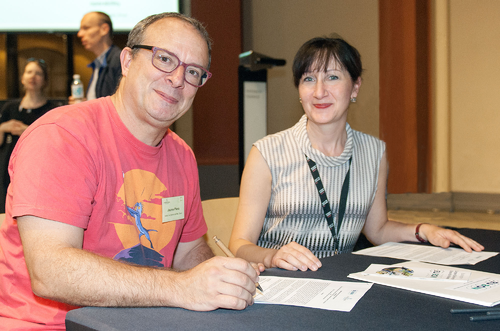
Photo: Signing the MoU between ECSA Chair of Data, Tools and Technology Committee Dr. Jaume Piera and EU BON's Project manager Anke Hoffmann; Credit: Hwaja Götz
A new position for "Researcher and Scientific Project Manager" is opened by the Doing it Together science (DITOs) project, running under the European Citizen Science Association (ECSA) within the H2020 framework, and led by the UCL London.
The DITOs project aims to elevate public engagement with science across Europe from passive engagement with the process of developing science to an active one.
Deadline: 23.05.2016
For more information on how to apply and requirements for this position, please download the Official Job Offer.
April proved to be an eventful month for EU BON, hosting the presentation of two major project results, not only within the same month, but in the course of one week. While CSIC and partners were launching the beta-version of the long-waited Biodiversity Portal in Seville, another EU BON team was busy to search for Integrated approaches for focused biodiversity data mobilization in Stockholm.
About the Portal:
In a dedicated session at the WP2 meeting in Seville, Spain, EU BON partners had the chance to view their work for the last couple of years materialising into one of the main expected project results - the European Biodiversity Portal. That said, what was then presented on 29 April is a beta version, with the final release of the portal planned to become available in early 2017.
Participants at the Seville Workshop, April 2016. Credit: A. Hoffmann
Nonetheless, this beta version already addresses the main aim to offer a unique service for analysing and understanding biodiversity change in Europe. For instance, users can explore how relative abundance of species (within a larger group) changes over time by using big data mediated by GBIF. There is also a spatial browser for locating datasets in any part of the world, which may be usable for computing the EBVs for species populations.
Additionally, an online analytical data processing (OLAP) toolbox has been included in this release. Based on GEOSS technology, the new portal lets users harvest and simultaneously access data from several directories, including GBIF, LTER, EuMon (coming), PESI, and GEOSS sources.
This release also highlights the products of the EU BON project, including new methods and analyses packed in factsheets and infographics for the convenience of scientists and policy users alike. Explore the portal’s beta version here.
Suggestions of how to develop the beta portal further towards the full release are appreciated. Use the feedback form at the welcome page.
Integrated biodiversity data mobilization:
It is a challenge for Bioinformatics group in Europe and around the world to find better ways to integrate different systems and technology. In EU BON’s Task 1.4 the approach to solving this issue was to integrate different systems managing natural history collections and molecular data systems using the best techniques available.
In a dedicated workshop, which took place in Stockholm, Sweden, developers in the sphere of bioinformatics were presented with the project’s Data Mobilization Toolkit. This particular workshop was mainly focused on Docker as a tool to move towards a more integrated environment. Docker has revolutionized system integration and in the workshop the Swedish team shared their experience with dockerizing the DINA-system.
Discussions during the Stockholm workshop; Credit: Karin Karlsson
The workshop ended with a hackathon where they together explored the possibilities for using Docker in selected parts of integrating Pluto-F, JACQ and DINA.
A new EU BON acknowledged article looks at the recently introduced in scientific literature methods for constructing Spatially Explicit Rarefaction (SER) and their implication for ecologists and conservation biologist. The research was published in the journal Ecological Indicators.
Abstract:
Recently, methods for constructing Spatially Explicit Rarefaction (SER) curves have been introduced in the scientific literature to describe the relation between the recorded species richness and sampling effort and taking into account for the spatial autocorrelation in the data. Despite these methodological advances, the use of SERs has not become routine and ecologists continue to use rarefaction methods that are not spatially explicit. Using two study cases from Italian vegetation surveys, we demonstrate that classic rarefaction methods that do not account for spatial structure can produce inaccurate results. Furthermore, our goal in this paper is to demonstrate how SERs can overcome the problem of spatial autocorrelation in the analysis of plant or animal communities. Our analyses demonstrate that using a spatially-explicit method for constructing rarefaction curves can substantially alter estimates of relative species richness. For both analyzed data sets, we found that the rank ordering of standardized species richness estimates was reversed between the two methods. We strongly advise the use of Spatially Explicit Rarefaction methods when analyzing biodiversity: the inclusion of spatial autocorrelation into rarefaction analyses can substantially alter conclusions and change the way we might prioritize or manage nature reserves.
Original Source:
Bacaro, G., Altobelli, A., Camelletti, M., Ciccarelli, D., Martellos, S., Palmer, M.W., Ricotta, C., Rocchini, D., Scheiner, S.M., Tordoni, E., Chiarucci, A. (2016). Incorporating spatial autocorrelation in rarefaction methods: implications for ecologists and conservation biologists. Ecological Indicators, 69: 233-238. [5years-IF: 3.494] doi: http://dx.doi.org/10.1016/j.ecolind.2016.04.026
A new EU BON acknowledging data article provides a virtual species set as a valuable tool in biodiversity monitoring.
Predicting species potential and future distribution has become a relevant tool in biodiversity monitoring and conservation. In this data article we present the suitability map of a virtual species generated based on two bioclimatic variables, and a dataset containing more than 700,000 random observations at the extent of Europe. The dataset includes spatial attributes such as: distance to roads, protected areas, country codes, and the habitat suitability of two spatially clustered species (grassland and forest species) and a wide-spread species.
Original Source:
Garzon-Lopez, C.X., Bastin, L., Foody, G.M., Rocchini, D. (2016). A virtual species set for robust and reproducible Species Distribution Modelling tests. Data in Brief, 7: 476-479. doi: http://dx.doi.org/10.1016/j.dib.2016.02.058

Applications for a Project Manager position for the Horizon 2020 project called COOP+ are now open at the University of Granada (Spain). This project aims to foster the cooperation among EU environmental research infrastructures (EISCAT, ICOS, EMSO, LifeWatch) and their international counterparts (NEON, TERN, AMERIFLUX, LBA, ILTER, OOI, AMISR, IMOS, etc.).
The Project Manager will be in contact with the project consortium on a daily basis to foster the cooperation among RIs. He/she will be responsible for communication with project partners (organizing meetings, workshops and videoconferences during the project duration, maintenance of web page). He/she will also participate in writing reports, timely production of deliverables as well as scientific outputs. He/she will join the "Laboratory of ecology" located in theAndalusian Institute for Earth System Research, at the University of Granada (Spain).
More infornation on the position, requirements and how to apply can be found in the offcial job offer.
Registration for the "10th GEO European Projects Workshop" is now open until 2 May 2016. The event this year will take place in Berlin, Germany, spanning over three days from 31 May to 2 June 2016.
To register and learn more, please click here.
An EU BON-Team from the Museum für Naturkunde will also organize a Break Out Session at the event. The dedicated session #11 is called "Challenges for Biodiversity and Ecosystem Observation for the Next Ten Years", where several EU-projects will present their current and future activities with regards to biodiversity and ecosystem data, knowledge and contributions to the GEO work. This will be followed by interactive World Cafés:
- World Café desk I: EEA and policy – data/model/portal needs.
- World Café desk II: Follow-up joint products of GEO EU Biodiversity projects.
- World Café desk III: Strengthening the in-situ approach in GEO by biodiversity and ecosystem-related projects.
- World Café desk IV: Connecting with other GEO Societal Benefit Areas (SBAs), e.g. Agriculture, Health.
The importance of measuring species diversity as an indicator of ecosystem health has been long recognized and it seems that satellite remote sensing (SRS) has proven to be one of the most cost-effective approaches to identify biodiversity hotspots and predict changes in species composition. What is the real potential of SRS and what are the pitfalls that need to be avoided to achieve the full potential of this method is the topic of a new research, published in the journal Remote Sensing in Ecology and Conservation.
The new study, supported by the FP7 funded EU project EU BON takes the assessment of diversity in plant communities as a case study. Showing the difficulties to achieve high results by relying only on field data, the paper discusses the advantages of SRS methods.
"In contrast to field-based methods, SRS allows for complete spatial coverages of the Earth's surface under study over a short period of time. Furthermore, it provides repeated measures, thus making it possible to study temporal changes in biodiversity," explains Dr. D. Rocchini from Fondazione Edmund Mach, lead author and WP deputy leader / task leader in EU BON. "In our research we provide a concise review of the potential of satellites to help track changes in plant species diversity, and provide, for the first time, an overview of the potential pitfalls associated with the misuse of satellite imagery to predict species diversity. "
Traditionally, assessment of biodiversity at local and regional scales relies on the one hand on local diversity, or the so called alpha-diversity, and on the other, on species turnover, or beta-diversity. Only in combination of these two measures can lead to an estimate of the whole diversity of an area.
While the assessment of alpha-diversity is relatively straightforward, calculation of beta-diversity could prove to be quite challenging. This is where increased collaboration between the remote sensing and biodiversity communities is needed in order to properly address future challenges and developments.
The new research shown the high potential of remote sensing in biodiversity studies while also identifying the challenges underpinning the development of this interdisciplinary field of research.
"Further sensitivity studies on environmental parameters derived from remote sensing for biodiversity mapping need to be undertaken to understand the pitfalls and impacts of different data collection processes and models. Such information, however, is crucial for a continuous global biodiversity analysis and an improved understanding of our current global challenges."concludes Dr. Rocchini.
Original Source:
Rocchini, D., Boyd, D. S., Féret, J.-B., Foody, G. M., He, K. S., Lausch, A., Nagendra, H., Wegmann, M., Pettorelli, N. (2016), Satellite remote sensing to monitor species diversity: potential and pitfalls. Remote Sensing in Ecology and Conservation, 2: 25-36. doi: 10.1002/rse2.9
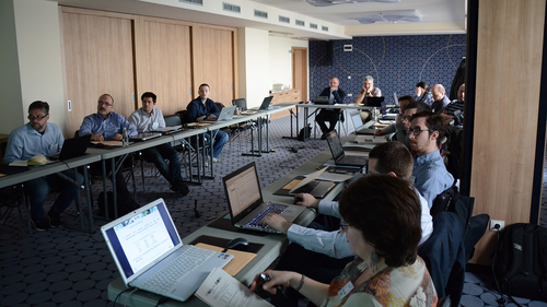
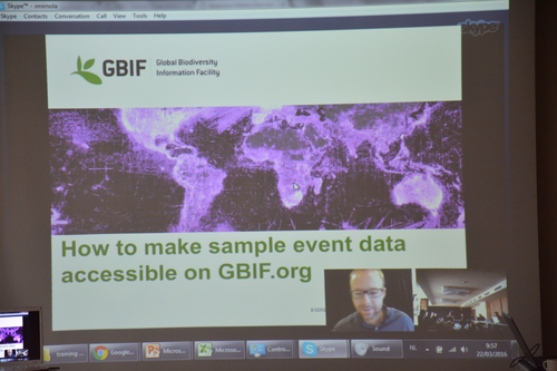
Open access to biodiversity is key for addressing pertinent ecological issues such as biodiversity loss and impacts of climate change. On 22 & 23 March 2016, experts from EU BON met with scientists, policy makers and practitioners from across Europe to discuss issues of biodiversity data sharing, curation and publishing.
The workshop, which took place in Sofia, Bulgaria, introduced participants to key concepts, demonstration and practical exercise in biodiversity data sharing using the GBIF Integrated Publishing Toolkit (IPT). Practical training sessions led by Larissa Smirnova from the Royal Museum for Central Africa (Belgium) and Kyle Braak from GBIF demonstrated the integration and management of datasets in GBIF. A step-by-step demo and practical session on how to publish a data was also featured in the workshop.
Participants at the EU BON data sharing & data publishing workshop in Sofia; Credit: Pensoft
Special attention was paid to innovative data publishing practices in a session led by the local hosts Pensoft Publishers who introduced their ARPHA publishing platform, as well as its new journal Research Ideas & Outcomes (RIO), which publishes unconventional output types across the research cycle, including data and software descriptions, workflows, methods and many more.
PlutoF demonstrated its citizen science gateway and demonstrated how the citizen science data can be managed using the CS module. Plazi also presented their GoldenGate Imagine tool, optimized for marking up, enhancing, and extracting text and data from PDF files.
Sessions at the at the EU BON data sharing & data publishing workshop in Sofia; Credit: Pensoft
Engagement with relevant political authorities and other stakeholders is of crucial importance for a research project, making sure its objectives are in tune with the real-world problems and its results provide adapted solutions. Now EU BON shares the outcomes, lessons learned and conclusions from a series of three roundtable meetings designed to identify stakeholder needs and promote collaboration between science and policy.
The collection of EU BON stakeholder roundtable reports provides a summarized overview of shared experiences gained in the three different workshops that were organized from 2013-2016. With more than 100 participants from over 20 countries altogether, the roundtable reports provide insights and exchange of ideas on highly relevant issues concerning policy, citizen science and local/regional stakeholders and its networks.
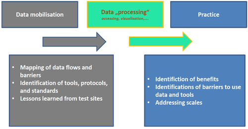
Simplified workflow from data mobilization via processing to stakeholders from the practice; Credit: Vohland et al.
The roundtables seek to build up a stakeholder dialogue with exemplary sector-specific user communities to incorporate feedback loops for the products of EU BON, as well as to develop improvements of existing biodiversity data workflows. Being published via the innovative Research Ideas & Outcomes (RIO) journal conclusions, derived knowledge and results are now made available for other projects and the wider community to ensure their re-use.
The three roundtable papers report on conclusion on highly relevant issues related to biodiversity information and its open-access and availability, data workflows and integration of citizen science as well as science-policy interfaces.
"In each of the three detailed reports of the roundtables we outline its aims, intentions, as well as results and recommendations, that were drafted based on the roundtable discussions, world café sessions and working groups. Such project results are now published for the first time in the new series of EU BON results, featured in RIO, providing a unique new medium to share experiences, outcomes and conclusions," comments Dr. Katrin Vohland, Museum für Naturkunde, Berlin.
"The three reports were published as workshop report provided by the Research Ideas & Outcomes (RIO) journal. This allows readers to publish, distribute and computationally analyse myriads of workshop reports that otherwise often get forgotten or just lost," comments Prof. Lyubomir Penev, co-founder and publisher of RIO.
Original Sources:
Wetzel F, Hoffmann A, Häuser C, Vohland K (2016) 1st EU BON Stakeholder Roundtable (Brussels, Belgium): Biodiversity and Requirements for Policy. Research Ideas and Outcomes 2: e8600. doi: 10.3897/rio.2.e8600
Vohland K, Häuser C, Regan E, Hoffmann A, Wetzel F (2016) 2nd EU BON Stakeholder Roundtable (Berlin, Germany): How can a European biodiversity network support citizen science? Research Ideas and Outcomes 2: e8616. doi: 10.3897/rio.2.e8616
Vohland K, Hoffmann A, Underwood E, Weatherdon L, Bonet F, Häuser C, Wetzel F (2016) 3rd EU BON Stakeholder Roundtable (Granada, Spain): Biodiversity data workflow from data mobilization to practice. Research Ideas and Outcomes 2: e8622. doi: 10.3897/rio.2.e8622
General synthesis and lessons learnt from the three EU BON stakeholder roundtables
Creating and maintaining a biodiversity data collection has been a much-needed worldwide exercise for years, yet there is no single standard on how to do this. This has led to a myriad of datasets often incompatible with each other. To make the most out of biodiversity data and to ensure that its use for environmental monitoring and conservation is both easy and legal, EU BON published recommendations that provide consistent Europe-wide Data Publishing Guidelines and Recommendations in the EU BON Biodiversity Portal.
The report "Data Policy Recommendations for Biodiversity Data. EU BON Project Report" featured in the Research Ideas & Outcomes (RIO) journal, is the first contribution in a pioneering comprehensive project outputs compilation taking advantage of RIO's unique option to publish collections of project results.
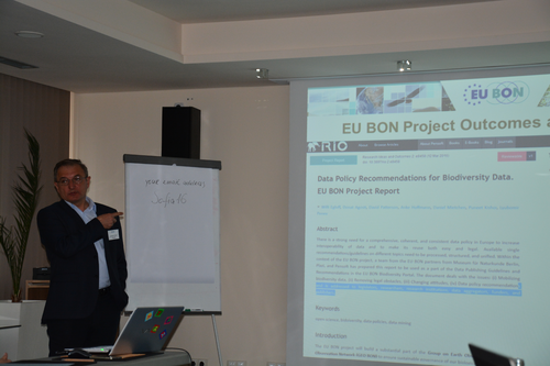
Lyubomir Penev presenting the EU BON collection in RIO at the project's biodiversity data sharing and data publishing workshop in Sofia; Credit: Pensoft
Biodiversity data and information provide important knowledge for many biological, geological, and environmental research disciplines. Additionally, they are crucial for the development of strong environmental policies and the management of natural resources. Information management systems can bring together a wealth of information and a legacy of over 260 years of biological observations which are now dispersed in a myriad of different documents, institutions, and locations.
EU BON aims to build a comprehensive "European Biodiversity Portal" that will incorporate currently scattered Europe-wide biodiversity data, while at the same time helping to realize a substantial part of the worldwide Group on Earth Observations Biodiversity Observation Network (GEO BON). To achieve this ambitious plan, EU BON identifies the strong need for a coherent and consistent data policy in Europe to increase interoperability of data and make its re-use both easy and legal.
"Biodiversity data and information should not be treated as commercial goods, but as a common resource for the whole human society. The EU BON data sharing agreement is an important step in this direction," comments the lead author of the report Dr. Willi Egloff from Plazi, Switzerland.
In its report, the EU BON project analysis available single recommendations and guidelines on different topics. On this basis, the report provides structured guidelines for legislators, researchers, data aggregators, funding agencies and publishers to be taken into consideration towards providing standardized, easy-to-find, re-shareable and re-usable biodiversity data.
"We are extremely happy that EU BON is among the first to take advantage of our project outputs collections option in RIO. The first report they are publishing with us deals with issues of opening up data, and digitizing and collecting scientific knowledge, all close to RIO's mission to open up the research process and promote open science," says Prof. Lyubomir Penev, Founder and Publisher of RIO.
Original Source:
Egloff W, Agosti D, Patterson D, Hoffmann A, Mietchen D, Kishor P, Penev L (2016) Data Policy Recommendations for Biodiversity Data. EU BON Project Report. Research Ideas and Outcomes2: e8458. doi: 10.3897/rio.2.e8458
From 26 to 28 January 2016, EU BON hosted its first Biodiversity Portal Hackathon in Seville, Spain. The event marked an important milestone for the project, paving the way towards one of the most important EU BON products - the European Biodiversity Portal.
It is a well known fact that current biodiversity observation systems and environmental datasets are unbalanced in coverage and not well integrated. This brings the need of a new system which will facilitate access to such knowledge and will effectively improve the work in the field of biodiversity observation in general.
Participants at the Biodiversity Portal Hackathon in Seville, Spain; Credit: Pensoft
The ultimate goal of EU BON is to create an European Biodiversity Portal which will collect and present biodiversity data from across Europe in a consistent and re-usable way. The portal will then feed into a global equivalent developed by the Group on Earth Observation’s Biodiversity Observation Network (GEO BON).
But what are the benefits from and what are the challenges in front of such an ambitious project?
Following the Biodiversity Data Portal hackathon, Dr. Hannu Saarenmaa, leader of WP 2 Data integration and interoperability, and Juan José Negro answered these questions in a video interview:

Recommendations from the FP7-funded EU project BESAFE
Biodiversity decline is a fact, but how can society be convinced of the benefits of biodiversity for human well being and of the necessity of further protective action? The FP7 funded EU project Biodiversity and Ecosystem Services: Arguments for our Future Environment (BESAFE) addressed this challenge to produce guidance that can help improve the way we use arguments for conservation and convincingly demonstrate the value of biodiversity to decision-makers.
Credit: Rob Bugter
Two key outputs of the project are the final brochure "How to Argue for Biodiversity Conservation More Effectively: Recommendations from the BESAFE project", including key conclusions from project publications and case studies, and an interactive online tool, which can lead stakeholders to the relevant information in a few mouse clicks.
Key recommendations of BESAFE featured in these resources are:
- The success of a more integrated approach depends on stakeholder engagement. A top-down policy framework that sets goals for the protection of particular sites and species is important, but it is not enough to prevent biodiversity loss. - -- An integrated approach, seeking to 'mainstream' biodiversity concerns across all policy sectors (e.g. agriculture, forestry, water, energy, transport and urban planning) is needed.
- Promote bottom-up initiatives at the local level. All stakeholders need to be actively involved in the decision-making process, which should facilitate building trust and working towards generally agreed and accepted solutions.
- Tailor arguments to the audience. Arguments need to be framed to fit the values and goals of the audience, embracing the plurality of values attached to nature, and using appropriate language. For example, over-emphasising economic arguments could alienate people who are motivated mainly by ethical and moral concerns.
- Use positive arguments. Positive framing of arguments to emphasise benefits is often more powerful than negative framing that focuses on threats and losses. The concept of ecosystem services is useful for emphasising positive benefits, provided that it is properly explained to stakeholders.
- Use a wider range of arguments. Arguments based on the economic value of nature for humans dominate European and national policy-making, and are often seen as central to gaining high-level policy-maker support, but our results show that many decision-makers and other stakeholders also use and respond positively to ethical and moral arguments.
"We aimed to provide the essence of 4 years worth of research in an easy to read and reuse form, to maximise the potential of using the right arguments for conservation at the right time in order to successfully demonstrate the value of biodiversity to decision-makers," comments Rob Bugter, co-ordinator of the BESAFE project.
Try out the resources below:
Bugter R., Smith A.C. and the BESAFE consortium. 2015. How to argue for biodiversity conservation more effectively. Recommendations from the BESAFE project. Pensoft Publishers, Sofia, 26 pp. Available at: http://www.
BESAFE web tool available at: http://tool.
MUSE (Museo delle Scienze) joined EU BON's Associated Partners family in November 2015. We are now happy to present some more information about the museum and its initiative - the TEAM network.
MUSE is involved in biodiversity monitoring both locally in Trento Province, southeastern Alps, and globally. In particular, its Tropical Biodiversity Section runs a long-term biodiversity research and monitoring programme in the Udzungwa Mountains of Tanzania, an outstanding site for biological diversity and endemism. In 2009, this site became the first in Africa to enter the TEAM Network, a global programme for the standardized monitoring of biodiversity across the tropical moist forests.
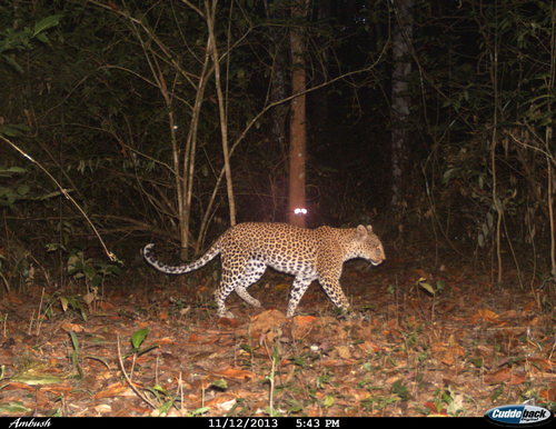
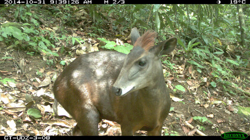
Camera trap images from the MUSE site in Tanzania; Credit: MUSE – Science Museum
Started in 2002 by Conservation International (CI), the Tropical Ecology Assessment and Monitoring (TEAM) Network (http://www.teamnetwork.org/ ) – grew to a coalition in 2009 that includes CI, the Smithsonian Tropical Research Institute and the Wildlife Conservation Society. TEAM has collected and made publicly available more than 2.5 million photos from camera traps in tropical forests across the planet. With support from Hewlett Packard Enterprise, formerly Hewlett Packard Company, the TEAM Network is now able to analyze this global data set in near real-time and provide data-driven insights for improving natural resource management.
A major analysis of TEAM data was recently published in PloS Biology and caught vast media coverage as it represents the first standardized assessment of its kind for population trends of tropical forest mammals and terrestrial birds (http://journals.plos.org/plosbiology/article?id=10.1371/journal.pbio.1002357). TEAM researchers monitored 244 species of ground-dwelling mammals and birds in 15 protected areas spanning tropical regions in Central and South America, Africa and Southeast Asia. They analyzed more than 2.5 million pictures captured by more than 1,000 camera traps and found that 17% of the animal populations they monitor increased in number while 22% remained constant and 22% decreased. The Wildlife Picture Index (WPI) Analytics System was developed in partnership with Hewlett Packard Company.
WPI is an index that summarizes the occupancy trends at community level and is an official indicator to monitor progresses against the Aichi Targets under the CBD (http://www.bipindicators.net/wildlifepictureindex).
In 2015, MUSE – Science Museum established in a Natural Park in the Brenta Dolomites (near Trento) the first site in Europe of systematic camera trapping that adopts the standardized protocol developed by the TEAM Network. This entails the sampling of 60 camera trap locations within an area of 200-250 km2 for 30 days each year, to derive data that are suitable to occupancy analysis and that can allow, as demonstrated by the recent paper in PLoS Biology, to assess population trends using state-of-the-art ecological methods.
MUSE’s scientists hope that this protocol may attract the interest of other partners within the EU BON family that may be keen to replicate this sampling at other sites in Europe.
One of the main outputs of EU BON will be the establishment of an European Biodiversity Portal based on data collected and compiled from a variety of sources including earth observations but also observations and monitoring data from (local) sites. One of the main points of this portal is to serve as a substantial building block of a global biodiversity portal planned by the Group of Earth Observations project GEO BON.
But how will this portal be useful to stakeholders on a more local level - for example for people involved in questions connected to biodiversity across European regions? What will be the real benefits of it for biodiversity monitoring and conservation? Just a couple of weeks after the Third EU BON Stakeholder Round Table in Granada, Spain, Mr Clint Alibrandi from REDIAM (Environment and Water Agency in Andalusia) gives us his views on these questions.
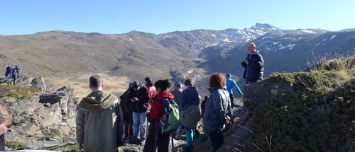
Picture: Excursion to Sierra Nevada.; Credit: Katrin Vohland
Q: REDIAM shares a mission with EU BON in its attempt to collect, standardize and distribute available biodiversity data. What will be the expected benefits and challenges in the process of making this type of datasets available for society and environmental policy?
A: Among the responsibilities of the Regional Environmental Government of Andalusia are promoting Social Environmental Awareness, Managing a vast, diverse and very complex territory, Control and Mitigate any threats posed to the fragile ecosystems present in our region as well as all the responsibilities derived from the management and planning of the existing natural resources.
Considering these facts, it is necessary to be able to account for the best environmental information available. Since the early 80’s the Regional Environmental Government of Andalusia has been working on its Environmental Information System with the purpose of generating, compiling, standardizing and analyzing Environmental Information covering topics such as Climate, Water, Air Quality and Biodiversity by means of ICTs. This the REDIAM. The name comes from the Spanish Acronym "REd De Información AMbiental de Andalucía" which means the Environmental Information Network of Andalusia. It serves as a Unified Regional Environmental Information Registry.
From this effort, the information obtained by the REDIAM is made publicly available to be then employed in Decision Making processes and Management Planning on behalf of the Administrations, for Dissemination and Awareness as well as for Research purposes.
As such, it is of vital importance for the REDIAM to be able to account for updated and verifiable Information and Data Sources and this is what we consider to be the most important benefit on behalf of EU BON, as it will offer the possibility to have a higher level reference covering a larger perspective, allowing stakeholders, be it either from a local, regional or national level, to consult or work with data, tools and have reference to relevant policies concerning Biodiversity on the European scale in order to be able to better transpose them to a more local context.
Yet the greatest challenge we believe that EU BON might come to face is the fact that the different contexts that exist over the whole European territory make it very difficult to tailor tools and information formats which can cover the different priorities or needs that exist in the diverse makeup of stakeholders that exist from a local, regional and national perspective. The same can most probably apply to the feedback, queries or requests made to EU BON on behalf of the stakeholder and user community. It is never easy to reach a common base level and from the regional perspective, REDIAM has faced the same type of situations.
Q: What type of stakeholders do you hope to engage through your network - who is using your data and for what purposes?
A: The stakeholders which are currently engaged with the REDIAM consist in Universities, Research Centres, Public Bodies, Local Administrations, Private Companies just to name a few examples. There are over 150 organizations which are partners of the REDIAM, they provide relevant Environmental Information to the REDIAM and are responsible for updating the information.
And as can be expected,the information provided is as diverse as the makeup of stakeholders that are part of the REDIAM, with the following formats being made available: Cartography, Satellites Images, Databases, Reports, Statistics, Applications, Management Plans and Programmes, Orthophotos, Indicators, Studies.
Additionally the REDIAM offers the user community different alternatives in order to access the previously indicated information. The REDIAM Channel is a web portal with a Catalogue and Information Search System, OGC Services, Query and Viewer tools, Downloader. The user community is able to access its information and services. This community consists in Citizens, Universities, Public Administrations and Companies from the Public and Private Sector.
Q: Where do you see the cross section between REDIAM’s work and EU BON - what are the products from EU BON and other European projects that would be helpful for the work that you are doing?
A: The REDIAM has great interest in the following issues and we believe that EU BON would be up to the task of providing solutions and/or guidelines on how to be able to proceed to solve them:
- The elaboration of a common tool for the description and localization of species throughout the European Territory. This can prove a very useful service for Environmental Impact Assessments by providing a more complete view on different species distribution on determined area.
- Defining a standardized list of species which contains the taxonomically correct name for each one of them. EU BON could serve as a base reference to set guidelines for standardizing the taxonomical classification of species.
- Support and guidance in defining specific biodiversity indicators as proposed by EUROSTAT, a methodological and assessment guide of some sort.
Q: In your opinion what are the three greatest benefits of a European level biodiversity portal?
A: 1) Offering an opportunity of Standardizing and Harmonizing Biodiversity related information. We all speak the same "language" when referring to Biodiversity, but it is necessary that we all be able to follow the same "rules" as well. This is the first and most important pillar we believe that a European level Biodiversity portal can bring into play.
2) It would allow for and facilitate a widespread exchange of information amongst stakeholders throughout the whole European Territory.
3) And finally, it would allow a common analysis on a European level which would provide a general assessment on how different efforts and policies are effective, value which is the real status of Biodiversity and/or specific species independently from the limit of administrative or country borders.
About REDIAM:
The Environmental Information Network REDIAM has onboard experts from the Regional Ministry of Environment in Andalusia and its Water and Environmental Agency. With a team expertise ranging from local to regional and European level and from technical know-how to regional and thematic assessment, the main aim of the network is to integrate all spatially-referenced biodiversity data produced in Andalusia. Raw data are used to generate knowledge and improve its distribution, making it accessible and comprehensible for the general public.


The Faculty of Geo-Information Science and Earth Observation (ITC) at the University of Twente has recently launched an investment programme to strengthen its international academic fields. For 11 pioneering-multidisciplinairy projects a PhD-position is made available, three of them already are filled in. The Department of Natural Resources (NRS) specialises in advanced spatial and temporal analysis and technique development for the environment as well as sustainable agriculture.
Job Description:
The aim of this PhD project is to develop a cloud based artificial neural network for processing large remotely sensed data sets in order to generate essential biodiversity variables (as defined by Pereira et al. (2013) and Skidmore et al. (2015)). The PhD candidate, in combination with supervisors and programming support, will develop innovative artificial intelligence techniques for estimating biodiversity variables using massive cloud based data sets of satellite remotely sensed, in situ and ancillary data. Potential candidate biodiversity variables to be retrieved from satellite remote sensing include pertinent indicators of ecosystem function, ecosystem structure and species traits. The research will result in a PhD thesis.
For more information visit the official job offer.
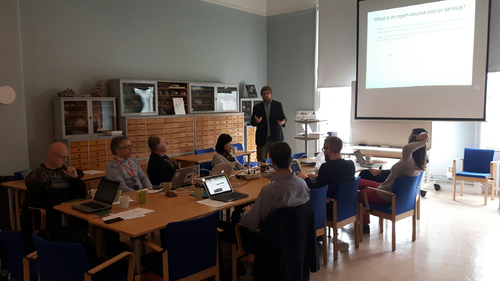
Are you in Eastern Europe and actively involved in monitoring and managing biodiversity data? Then the EU BON "Biodiversity data sharing and data publishing workshop" might just be the thing for you.
The event will take place on 22-23 March 2016 in Sofia, Bulgaria with focus on publishing of biodiversity data, in particular species occurrences, sample-based and citizen science data. The training will include a practical session during which participants will be assisted by experienced trainers from the EU BON project. To register and for more information, click here.

The sessions on data sharing will cover introductory overview of key concepts, demonstration and practical exercise using the GBIF Integrated Publishing Toolkit (IPT). The Global Biodiversity Information Facility (GBIF) is the world's largest initiative for enabling free access to biodiversity data via internet.
Special attention will be paid to data paper publishing led by specialists from Pensoft Publishers - a company well known among biodiversity scientists worldwide for technologically cutting-edge open access journals, such as: Research Ideas and Outcomes, ZooKeys, Biodiversity Data Journal, Nature Conservation, and a strong advocate of data publishing. Registration of data in GEO registry system will be also addressed during the workshop.
The following topics will be covered (detailed program will follow):
- The data publishing landscape, gaps and mobilization efforts
- Demonstration and practical session on data publishing using the GBIF IPT: step-by-step demo will show in detail (and in practice) how to publish a dataset using IPT.
- The Data Publishing Toolkit at EU BON: Automated creation of data papers, data and text integrated publishing via the ARPHA Publishing Platform
- Citizen Science gateway and demo of PlutoF Citizen Science module
- GoldenGate Imagine tool and copyright issues
- Registration of data in the GEO Registry System
Context and background:
Addressing global problems, such as biodiversity loss and impacts of climate change requires open access to data. This was concluded by world leaders at Johannesburg Summit in 2002 when they established the Group for Earth Observations (GEO). EU BON (Building the European Biodiversity Observation Network) seeks to enhance biodiversity data availability and integration, and is the European contribution to the GEO Biodiversity Observation Network.
All biodiversity databases need to be integrated in GEO. Therefore, EU BON undertakes capacity building of biodiversity communities (e.g. researchers, citizen scientists, non-governmental organisations) that are involved in collecting and disseminating biodiversity information, including monitoring initiatives.
To register and for more information, click here.

- Assistant Programme Officer – Marine Digital Products (AD 916) Deadline: 5th February 2016
- Assistant Programme Officer (AD 922) Deadline: 5th February 2016
EU BON has signed memoranda of understanding with almost thirty institutions and projects from across Europe and outside to state its desire for collaboration and exchange of expertise. Among the early partners in this list is the LTER-Europe group, focussed on the integration of scientific research and ecosystem research approaches, including the human dimension.
Dr. Mark Frenzel who took part in the EU BON Third Stakeholder roundtable in December 2015, gives an overview of his impressions from the meeting as well as his ideas on the co-work between LTER-Europe and EU BON.
Credit: Florian Wetzel
Q: The LTER-Europe network looks at conceptualizing Long-Term Ecosystem Research (LTER) as an essential component of world-wide efforts to better understand ecosystems. How is the network planning to achieve this?
 A: This is / will be achieved mainly by funded project work. Actually the H2020 eLTER project is the most important backbone, an ESFRI eLTER initiative is running too. In terms of content there are several challenges which need to be addressed: (1) Harmonisation in terms of what and how is being measured at LTER sites, (2) collection and representation of metadata about sites, actors and data sets within the web tool DEIMS, (3) open access of data and DOI registration of data sets, (4) considering the human component as a major driver for changes in ecosystems by including socio-economy and socio-ecology in the LTER approach.
Q: How would EU BON and its planned European biodiversity portal be beneficial to LTER-Europe and its aims in the next years?
A: Biodiversity is not the only, but an important focus within LTER. It depends on the services and benefits connected with this portal and its long-term perspective. The most important added value I would see in an elaborated framework-based agreement on the set of "essential biodiversity variables" which will be a compromise between importance and feasibility. This selection process should be well tuned with the relevant players in this field.
Q: The LTER-Europe network includes several hundreds of sites that are collecting large amounts of data – how can this data be used for improving our knowledge of biodiversity, particularly for policy-relevant questions?
A: The big advantage (and potential) of LTER-Europe sites is the coverage in terms of geography and bioms, the general shortcoming is in the heterogeneous reasons why these sites have been set up (e.g. for monitoring air pollution) and that there is no targeted funding (in terms of a specific research question) for all sites.
Not all sites are dealing with biodiversity data. First, suitable sites need to be selected according to metadata in DEIMS (https://data.lter-europe.net/deims/). Second, data sets according to fitting topics have to be compiled (perhaps no easy task, as datasets up to now are not exhaustively documented). Site managers of representative sites (depending on the question to be addressed) could be motivated to create a common standardised data sets (needs external funding depending on the resources necessary for the task or at least a very attractive research question) responding to e.g. policy needs. Moreover, the long-term knowledge of site coordinators about the development and the important drivers of change at their sites (e.g. by assessing ecosystem services) comprises valuable meta information about the context of data sets.
Data obtained from the sites could potentially help with policy-relevant questions like status of endangered species or status of ecosystem service relevant system parameters which could be extracted from LTER sites.
Q: According to you what are the next three most urgent step in order to achieve better understanding of ecosystem services and their benefits for policy, economics and society?
A: (1) reliable data and suitable scale of data, (2) understanding the effect of scale on ecosystem services, (3) make use of large networks to approach this issue, bring the results down to a scale understandable for the layman.
About LTER-Europe:
Long-Term Ecosystem Research (LTER) is an essential component of world-wide efforts to better understand ecosystems. LTER contributes to the knowledge base informing policy and to the development of management options in response to the Grand Challenges under Global Change. From the beginning (around 2003) the design of LTER-Europe has focussed on the integration of natural sciences and ecosystem research approaches, including the human dimension. LTER-Europe was heavily involved in conceptualizing socio-ecological research (LTSER). As well as LTER Sites, LTER-Europe features LTSER Platforms, acting as test infrastructures for a new generation of ecosystem research across European environmental and socio-economic gradients.